
What we have – mapping existing areas of importance
In the first step, existing areas that are of particular importance for biodiversity were mapped. What could be mapped at this stage was strictly defined by the LNRS regulations and guidance – therefore the “Areas of Particular Importance for Biodiversity” (APIB) data layer consists of national conservation sites, local nature reserves, local wildlife sites and irreplaceable habitats. The intention of this approach was to establish a nationally consistent baseline map of areas whose particular importance is already recognised and protected. This helps LNRSs align with local planning policy, integrate well with other environmental and land use policies and avoid duplication.
Although it isn’t included in this baseline map, during this stage of the work we will also identified other sites that may sit outside these defined areas but we know locally to be significant to our county’s nature resource – this mapping helped inform the spatial priorities of the LNRS.
Milestone completed.
The APIB map can be viewed online, through our mapping tool:
View the Kent & Medway LNRS Areas of Particular Importance for Biodiversity map
Project outputs
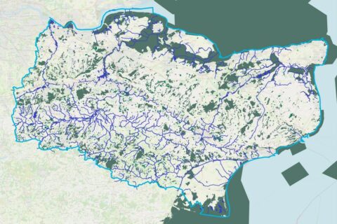
Kent & Medway LNRS Areas of Particular Importance for Biodiversity
Download PDF (2 MB) - Kent And Medway LNRS Areas Of Particular Importance For Biodiversity
Indicative work timeline
Background information
State of Nature in Kent
This landmark report is available here and features over sixty contributors across seven chapters. It will be used to inform development of the Kent and Medway Nature Recovery Strategy.

Get involved
We want to hear from you! You can also sign up for our mailing list and get in touch with us.